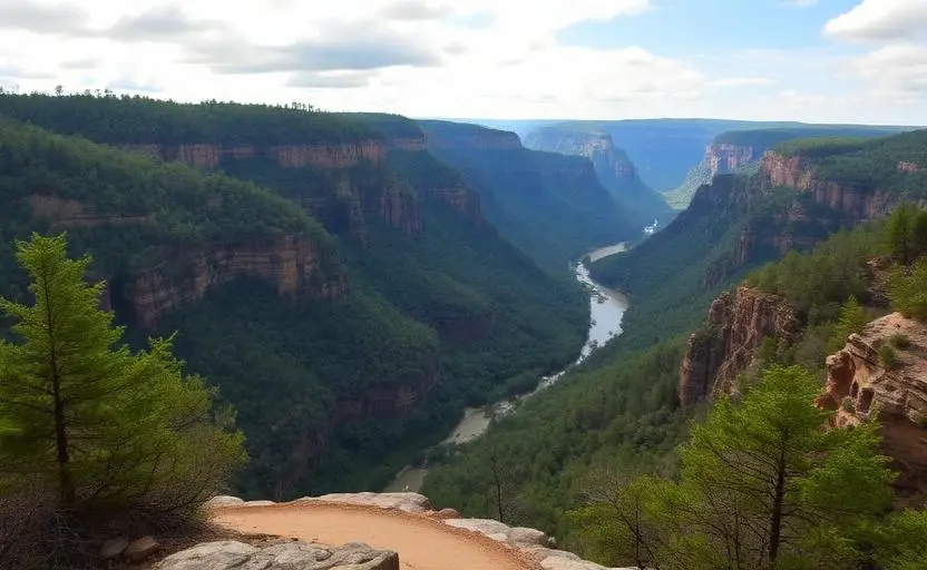
Little River Canyon Preserve
Little River Canyon Preserve is a moderate 30+ miles off-road trail near Fort Payne, AL, best run Year-round. The gear list marks All-terrain tires, 4WD capability and Tow strap as required, and Skid plates as recommended. A stock high-clearance 4x4 can run it; check the gear list before you go.
Trail Conditions
No reports yet
Little River Canyon National Preserve protects one of the most unique geological features in the eastern US, a deep canyon carved by a river that flows for most of its length atop a mountain. Lookout Mountain's flat summit channels Little River through a canyon up to 600 feet deep, creating dramatic cliff-lined views from forest roads along the rim. The canyon's unique position has created isolated habitat for rare plant and animal species found nowhere else, while the surrounding forest roads offer spectacular overlanding with canyon rim viewpoints.
Fun Facts
Little River is the longest mountaintop river in the US, flowing atop Lookout Mountain for most of its length.
The canyon is one of the deepest east of the Mississippi at up to 600 feet.
Grace's High Falls at 133 feet is the tallest waterfall in Alabama.
The preserve protects habitat for several rare and endemic species.
🛞 Tires
⚙️ Drivetrain
🪢 Recovery
🛡️ Protection
Closest campgrounds to Little River Canyon Preserve:
- Knotty Pine Resort · Fort Payne · 7 mi (straight-line)
- DeSoto State Park · Fort Payne · 7 mi (straight-line)
- De Soto State Park · Fort Payne · 7 mi (straight-line)
- Cedar Bluff RV Park · Cedar Bluff · 11 mi (straight-line)
- Hickory Knob Camp · Mentone · 13 mi (straight-line)
- Roosters Marina · Centre · 16 mi (straight-line)
Straight-line distance. Check the map for drive time.
GPS Coordinates
Import into Gaia GPS, OnX Offroad, or Garmin
Map of Fort Payne, AL
5-Day Forecast
Nearby Trails
WHAT YOU'LL NEED
A mild lift, all-terrain tires, and correct gear ratio will get you through this trail confidently.
Tire Size Calculator
Convert tire sizes and compare diameter differences before you swap.
Size up correctly, 33s vs 35s matters on moderate terrain.
Gear Ratio Calculator
Find the right gear ratio after lifting or upsizing tires.
Re-gear after a tire upgrade to restore trail torque and MPG.
Wheel Fitment Calculator
Calculate backspacing and offset so wider wheels clear your suspension.
Extra wheel width = extra clearance on tight lines. Check offset before buying.
MPG Calculator
Estimate fuel economy after a tire upgrade, important for remote runs.
Bigger tires cut MPG. Plan your fuel stops for this trail.