The water is the color of chocolate milk and moving faster than it looks. Your front bumper is a foot from the edge and the far bank looks a lot farther away than it did on the map. Nobody here is arguing about lockers. The only question is how deep the middle is, and nobody can see it.
That is the Kane Creek crossing on the way to Chicken Corners, and it is the part of this trail the brochures skip. The rest of the route is gravel, red dirt, sand and the odd shelf of bare sandstone. The club that rates Moab's trails calls it a dirt road that needs light-duty 4WD, meaning a truck or SUV with a real four-wheel-drive system and the ground clearance a rough dirt road asks for, not a rock crawler with lockers and a winch.
So the Chicken Corners trail is a beginner's Moab trip with one expert decision baked into it: whether to cross the creek. Get that right and you end up looking back across the river at the Dead Horse Point cliffs from below.
Why the Chicken Corners trail is in the news now
On Oct 6, 2026, Jeep announced that Moab had named it the Official 4x4 of Moab in a two-year deal approved by the city council. The same Stellantis release says Jeep, the Red Rock 4-Wheelers, the BLM Moab Field Office and Tread Lightly! will focus the official stewardship project of the 2027 Easter Jeep Safari on the Chicken Corners trail corridor. The release names no date, crew size or task list for that project.
The Red Rock 4-Wheelers, the club that runs the Safari, list Easter Jeep Safari 2027 as March 20 through March 28 on their home page. Our reading: if the cleanup happens during Safari week, that corridor will be busy in late March, and a quiet winter or early spring trip will look very different.
Then the weather made its own news. Moab Sun News reported on Nov 12, 2026 that heavy rain hit the Moab area in mid-October, and that a second multi-day storm just over a week later flooded Hunter Canyon and "caused temporary closures along Kane Creek road." Packrafters ran Kane Creek, an ephemeral creek, and the paper reports it kept flowing for 10 days. On Nov 4, the Moab Trail Marathon's race director told the paper Kane Creek was "still too high and fast to cross safely," and the race rerouted its courses "to avoid mud, quicksand and deep water in Kane Creek." The same day, one visitor's report on TrailsOffroad said Kane Creek Road was washed out near the creek, just before the turn west to climb Hurrah Pass.
None of that is an official BLM closure notice. We found none posted on the BLM's Chicken Corners page or BLM alerts as of Nov 13, 2026. It is a reason to call before you drive to Moab.
The honest truth about Chicken Corners
Two things the trail name hides.
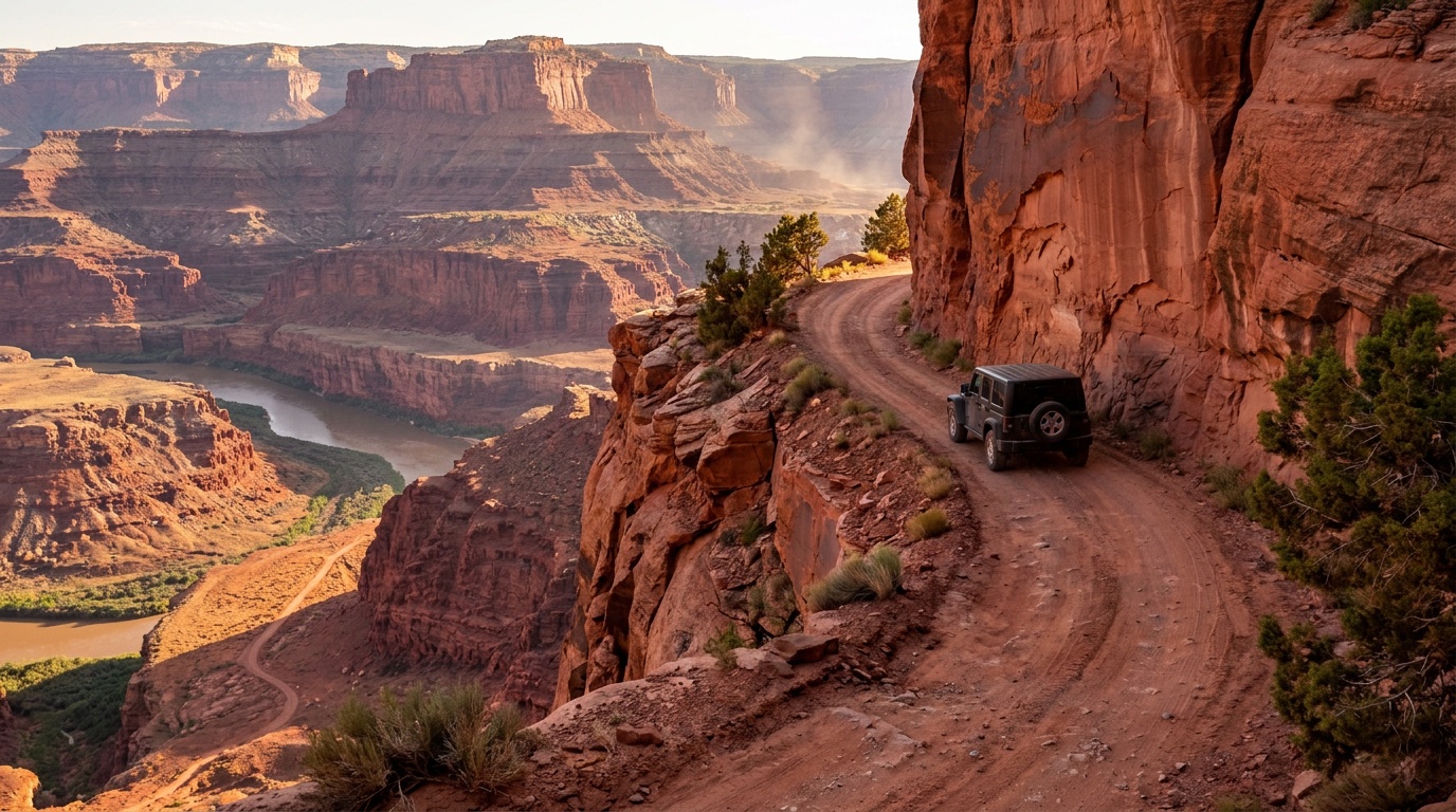
First, you do not drive the corner. The club's own Chicken Corners trail page says it plainly: "the actual Chicken Corners is a hiking trail." The name comes from the old pack trail, where "only the least 'chicken' passed." Today the vehicle trail ends across the river from Dead Horse Point, and the narrow bench that "tips toward the river 400 feet below" is on foot. If someone at camp promises you a white-knuckle ledge drive, they are selling the story, not the trail.
Second, the hard part is water, not rock. The same club page says the ford of Kane Creek "ranges from dry to window deep (impassible after a storm)." The club's ratings page adds a general warning that "heavy but localized rains can change Kane Creek from a moderate trail to impassable in an afternoon." Lockers do not help you there. Patience does.
Chicken Corners trail route: what you drive
The BLM's Chicken Corners Trailhead page describes the route as a 4x4 road that runs down the Colorado River canyon below Moab, follows Kane Springs Canyon, climbs the Kane Creek anticline to Hurrah Pass, then drops to benches above the Colorado River. It dead-ends about 400 feet above the river across from Dead Horse Point State Park.
Getting there is simple. From Main and Center streets in Moab, the BLM says to go south on Main 0.6 mile, turn right on Kane Creek Road, and follow it into the river canyon. The pavement ends near the Kane Creek area, and the BLM's directions note that non-licensed vehicles must start there.
| Stretch | What you are driving on | What it asks of you |
|---|---|---|
| Kane Creek Road, pavement | Paved road along the river | Nothing. Watch for bikes and race traffic on event weekends |
| Pavement end to Kane Creek ford | Gravel, then dirt and sand | High clearance; 4WD ready for soft sand |
| Kane Creek ford | Creek bed, dry to window deep per RR4W | Stop, walk it, turn back if you cannot see or wade it |
| Climb to Hurrah Pass | Red dirt, sand, occasional sandstone bedrock | 4WD, slow on the switchbacks |
| Down to the river benches and the end | Dirt, sand, bedrock; final mile on a bench about 400 ft above the river | Steady pace, eyes on the edge |
| Chicken Corners itself | Foot trail past the end of the vehicle trail | Park and walk |
RR4W lists the trail at 21 miles. It is out and back, so plan on about 42 miles of dirt and creek bed round trip (our math from RR4W's 21-mile length), plus the paved miles to and from town.
What you see on the Chicken Corners trail
The club's write-up is worth quoting. Lower Kane Springs Canyon is "even deeper and much narrower" than the Colorado River canyon. The climb to Hurrah Pass shows a wider stretch of the Colorado "more than 2,000 feet below the mesa tops." It lists petroglyphs at the roadside, "an unusual limestone arch" along the road, and a stop at a red rock mound with caves cut by erosion. The final mile runs on a bench about 400 feet above the river.
Chicken Corners trail difficulty: what rig it takes
RR4W rates Chicken Corners a 2. On the club's scale, a 2 is a "County dirt road with infrequent or light maintenance after rain or snow, high clearance light duty 4WD required." The trail page lists minimum tire size as "stock" and lists the winch, front locker and rear locker lines as "No."
In plain terms, by our reading of that rating:
- Stock high-clearance 4x4 with low range: yes. That covers a stock Wrangler, Bronco, Tacoma, 4Runner, Gladiator or full-size 4x4 pickup in dry conditions.
- AWD crossover: the club's own rating says 4WD is required. Take that seriously.
- 2WD truck: no, by the same rating.
- Built rig on 35s with lockers: fine, and overkill. Taller tires do not raise the water fording depth your owner's manual allows, and that number is the one that matters at the creek.
The number people want is the ford depth. We did not find a published one, and RR4W's own range runs from dry to window deep. Look up your truck's rated water fording depth in the owner's manual before the trip. If you cannot see the bottom or would not wade it, the depth question is already answered.
Honest warts
- The ford can strand you on the wrong side. Storms upstream can raise the creek while you are past it. RR4W calls it impassable after a storm. Bring enough food, water and warm layers to wait it out, because the fix may be waiting, not winching.
- Washouts move. One TrailsOffroad visitor report dated Nov 4, 2026, described a washout on Kane Creek Road just before the climb to Hurrah Pass. That is one report, not a survey or a BLM notice. The agency is the BLM Moab Field Office (435-259-2100), not NPS. No closure was listed on BLM alerts as of Nov 13, 2026.
- The name oversells the ending. The famous ledge is a walk. Go for the canyon, the pass and the view, not for an exposure drive.
- You share the road. The BLM directions say unlicensed OHVs start at the pavement end, so expect side-by-sides, dirt bikes and mountain bikers on the route.
- No services past town. The BLM visitor guide says no water is available in its developed campgrounds. Fill up and fuel up in Moab.
Chicken Corners camping rules
This is where good trips turn into tickets. The BLM Moab visitor guide sets out the rules.
- Developed campgrounds on Kane Creek Road include King's Bottom, the Hunter Canyon Group Site and the Ledge campgrounds. The guide says "most camping fees are $20/night per site," first come, first served, with vault toilets and fire rings but no water.
- Designated backcountry sites are marked with a tent symbol on a brown post. The guide says camping must stay inside the boundaries of a marked site.
- Toilets: the visitor guide says portable toilet systems "are required for public land users throughout Grand County if no toilet is available," and a portable toilet or human waste bag "is required for all dispersed camping." The 2016 supplementary rules (govinfo PDF), the enforceable Moab Field Office waste rules, apply that requirement only in listed high-use areas and do not name this route. Pack a toilet anyway, because the official guide requires one where no toilet is provided. Take waste bags to the Moab Transfer Station, not a BLM dumpster.
- Firewood: no gathering or cutting. Buy it in town.
- Stay limit: the guide says 14 days at one location, then move at least 30 miles. The BLM's Ledge Campground page words it as 14 nights in a 30-day period. Plan a weekend and neither matters.
- The Ledge payment line: the BLM Ledge page says pay at the campground, cash or check only. The visitor guide says card payment is available at Ledge B. Bring cash or a checkbook and you are covered either way.
- Size limit: the BLM says the Ledge and Hunter Canyon group sites sit down tight, steep switchbacks and are not recommended for vehicles over 22 feet or long trailers. Its Ledge group page also warns that Ledge E "is accessed by crossing the Kane Creek drainage, which periodically floods during storms."
Visitors from out of state: what Utah needs from you
For a street-legal Jeep or truck, nothing extra. Utah's Division of Outdoor Recreation says "an ordinary car, Jeep or truck registered as a passenger vehicle does not need an OHV permit simply because it is driven on an unpaved road."
Bringing a side-by-side, ATV or dirt bike is different. Utah's non-resident OHV permit FAQ says the permit is $35 per machine and valid for 12 months from purchase, and that since Sept 8, 2026 out-of-state OHVs need it even when registered street legal at home, with limited exceptions. The division says it keeps no list of reciprocating states and that reciprocity does not replace the permit. Rider education is a separate requirement. Allow time: the FAQ says up to 20 business days for the physical permit, with an emailed temporary permit to carry meanwhile. A permit bought in November 2026 still covers Safari week in late March.
What to buy, and what to skip, for Chicken Corners
| Spend on | Why | Skip for this trail |
|---|---|---|
| Portable toilet system or waste bags | Required by the official BLM visitor guide where no toilet is provided | Lift kit |
| Extra water and a cooler of food | No water in BLM campgrounds; a high creek can hold you on one side | 35s or 37s |
| Paper map or offline track | RR4W posts a downloadable KML track on the trail page | Lockers and a winch for this route |
| A way to call or message out | You may need to report you are waiting out the creek | Rock sliders, unless your next trail needs them |
| Firewood from town | Gathering is not allowed | Chainsaw |
If you are building toward harder Moab trails anyway, fine. Just do not let anyone sell you a lift for this one.
Verdict: is the Chicken Corners trail worth it?
| Question | Answer | Source |
|---|---|---|
| Can a stock 4x4 do it? | Yes, a high-clearance 4WD on stock tires in dry conditions | RR4W rating 2, minimum tire "stock" |
| Can an AWD crossover do it? | Not by the club's rating, which requires 4WD | RR4W ratings page |
| How long is it? | 21 miles each way, about 42 round trip | RR4W; round trip is our math |
| What can end the trip? | The Kane Creek ford, dry to window deep | RR4W trail page |
| Do you drive Chicken Corners itself? | No, it is now a hiking trail | RR4W trail page |
| Is it open right now? | Unconfirmed; storms in late Oct 2026 closed parts of Kane Creek road | Moab Sun News; call BLM 435-259-2100 |
| What camp rule catches people? | Official visitor guide requires a portable toilet where no toilet exists; the 2016 rules do not name this route | BLM visitor guide; 81 FR 9498 |
Who should drive Chicken Corners, and who should not
Drive it if you have a stock or lightly modified 4x4, you want a first Moab trail that is mostly about the view, and you will turn around at the creek without feeling cheated.
Skip it, or pick a different day, if the forecast shows rain upstream, if you are towing anything long, if you are in an AWD crossover, or if your plan only works when the creek is low on the one day you have. If you want rock, Moab has plenty of harder trails. This is not the one.
Bottom line
The Chicken Corners trail is the Moab trip a stock 4x4 owner should do first: 21 miles each way of canyon, petroglyphs and a pass, ending on a bench about 400 feet above the Colorado. Skip the lift. Pack a portable toilet, extra water and a willingness to turn around at Kane Creek, and call the BLM before you go this fall.
Internal links
- Moab Trail Collection
- Easter Jeep Safari 2026
- Camping near trails in Utah
- Dispersed Camping 101
- Leave No Trace for overlanders
Sources
- BLM, Chicken Corners Trailhead (route description, directions, non-licensed vehicle start point, 435-259-2100), checked Nov 13, 2026
- Red Rock 4-Wheelers, Chicken Corners trail page (rating 2, 21 miles, minimum tire stock, winch and lockers "No," ford "dry to window deep," hiking-trail note), checked Nov 13, 2026
- Red Rock 4-Wheelers, Trail Ratings (rating 2 definition, Kane Creek weather note), checked Nov 13, 2026
- Red Rock 4-Wheelers, home page (Easter Jeep Safari 2027, March 20 to 28), checked Nov 13, 2026
- Stellantis, "Jeep Brand Named the Official 4x4 of Moab," Oct 6, 2026
- BLM Moab Visitor Guide PDF (fees, designated sites, portable toilets, firewood, 14-day limit, no water), checked Nov 13, 2026
- BLM Moab Camping Map PDF (map; little extractable text)
- BLM, The Ledge Campground ($20 per night, cash or check, 14 nights in 30 days)
- BLM, The Ledge Group Sites (22-foot advisory, Ledge E flood warning)
- BLM, Hunter Canyon Group Site (22-foot advisory)
- Utah Division of Outdoor Recreation, Non-Resident OHV Permit FAQs ($35, 12 months, passenger vehicle answer, Sept 8, 2026 street-legal rule, 20 business days), checked Nov 13, 2026
- Utah Division of Outdoor Recreation, Street-Legal OHV Requirements (effective Sept 8, 2026 rule and limited exceptions; the page cites Utah Code 41-22-35(1)(b) for one exception), checked Nov 13, 2026
- Utah Division of Outdoor Recreation, Non-Resident OHV Permits ($35, 12 months, Sept 8, 2026 street-legal line)
- Final Supplementary Rules for Public Lands Managed by the Moab and Monticello Field Offices, 81 FR 9498, Feb. 25, 2016 (official govinfo PDF) (portable-toilet rule limited to listed high-use areas; Kane Springs Creek Canyon Rim route is listed, Chicken Corners and Kane Creek Road are not named)
- Moab Sun News, "Not for novices: Moab's expert packrafters run a rare Kane Creek flow," Nov 12, 2026
- Moab Sun News, "Expect traffic and brief closures on Kane Creek for Saturday's trail championship," Nov 6, 2026
- TrailsOffroad, Hurrah Pass trail reports (visitor report dated Nov 4, 2026, "Temporary Closure"), checked Nov 13, 2026
- BLM alerts (no Kane Creek or Chicken Corners closure listed), checked Nov 13, 2026